


2022-04-12_15h08m07_52-St_Aignan_de_Cramesnil-9270182-1649768875-944

phi14
User
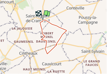

Length
8.7 km

Max alt
108 m

Uphill gradient
73 m
Km-Effort
9.6 km

Min alt
66 m

Downhill gradient
72 m
Boucle
Yes
Creation date :
2022-04-12 13:08:07.99
Updated on :
2022-04-12 13:27:53.901
0m
Difficulty : Easy

FREE GPS app for hiking
 SityTrail
IGN / Geographical institutes
SityTrail Plus
The world is yours!
About
Trail Nordic walking of 8.7 km to be discovered at Normandy, Calvados, Le Castelet. This trail is proposed by phi14.
Positioning
Country:
France
Region :
Normandy
Department/Province :
Calvados
Municipality :
Le Castelet
Location:
Saint-Aignan-de-Cramesnil
Start:(Dec)
Start:(UTM)
698995 ; 5439942 (30U) N.
Comments